The NM Groundwater Explorer brings together decades of groundwater monitoring, geologic mapping, and water-use records into a single interactive map. It was built to help water managers, researchers, and the public see how New Mexico's groundwater resources are changing over time, and to make the state's own data easier to explore without specialized GIS software.
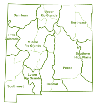
New Mexico's groundwater is organized into ten groundwater regions, each further divided into subregions, reflecting the major aquifer systems and basins that shape how water moves underground across the state. Zooming in on the map reveals a region's own subregions, letting you narrow any data layer down to the specific area you're interested in.
- Water Quality
- Depth to Water
- Change in Depth to Water
- Water Use Categories
- Contamination Sources
- Monitoring Locations
- Surface Ownership
- Regulated Areas
- Geology
- Flow Paths
Stories walk through a specific water-management question using a curated set of data layers, rather than leaving you to piece one together yourself. For example, a story on groundwater decline in the Roswell Artesian Basin might step through historical Depth to Water readings, the Change in Depth layer showing where levels have dropped fastest since 1980, and nearby Water Use Categories, to build up a picture of how pumping and recharge have shaped that basin over time.